
TL;DR:
- Researchers at Karlsruhe Institute of Technology (KIT) use AI to enhance global climate models’ precipitation maps.
- Achievements include a tenfold increase in temporal resolution (from one hour to ten minutes) and a substantial spatial resolution boost (from 32 to two kilometers).
- A Generative Adversarial Network (GAN) trained on high-resolution radar data is at the core of this innovation.
- Conventional models lack the precision to capture precipitation variations effectively.
- The GAN model excels in reconstructing extreme value distribution and exhibits impressive skill scores.
- The methodology generates a range of plausible precipitation fields, improving forecasting accuracy.
- Higher resolution aids in estimating the impacts of extreme weather events in a warming world.
Main AI News:
In the face of escalating climate change, the world is experiencing an uptick in extreme weather events, particularly heavy precipitation occurrences. These phenomena bear a direct connection to a surge in natural disasters like floods and landslides. Climate prediction models have been instrumental in addressing these challenges, yet they demand a significant overhaul to accurately depict the increasingly volatile atmospheric conditions, largely attributed to rising global temperatures.
Enter the pioneering researchers at the Karlsruhe Institute of Technology (KIT), who have embarked on a transformative journey, leveraging the power of Artificial Intelligence (AI) to augment the precision of global climate models’ coarse precipitation maps. This groundbreaking endeavor seeks to revolutionize the spatial and temporal resolution of precipitation forecasting, thereby bolstering our ability to predict and mitigate the impacts of localized heavy precipitation events and their ensuing natural disasters.
One of the primary achievements of this endeavor is the remarkable reduction in temporal resolution from an hour to a mere ten minutes. Simultaneously, the spatial resolution has been magnificently enhanced, catapulting it from 32 kilometers to a mere two kilometers. This heightened resolution is nothing short of a game-changer, equipping us to more accurately anticipate the future occurrence of heavy local precipitation events and the consequential natural calamities they bring in their wake.
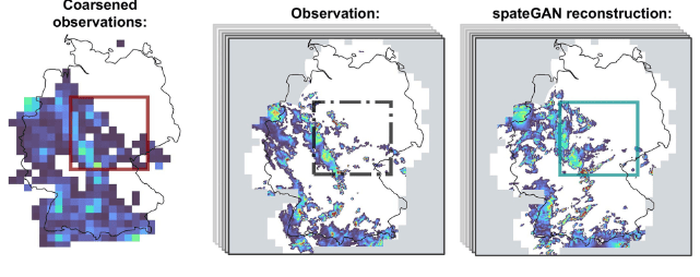
At the heart of this groundbreaking methodology lies the deployment of a generative neural network, specifically a Generative Adversarial Network (GAN). This sophisticated AI entity undergoes rigorous training, harnessing high-resolution radar precipitation data to learn and replicate realistic precipitation fields with unprecedented spatial and temporal finesse.
The existing global climate models rely on a grid system that lacks the essential granularity required to capture precipitation variations with precision. Furthermore, the traditional approach to producing highly detailed precipitation maps demands computationally intensive models, thereby imposing significant spatial and temporal constraints.
The brainchild of this groundbreaking innovation, the GAN, emerges as an AI-based generative neural network, meticulously tutored on high-resolution radar precipitation fields. This unique approach enables the GAN to distill complex information from coarsely resolved data, empowering it to craft authentic precipitation fields and decipher their temporal progression.
In comparison to conventional techniques such as trilinear interpolation and classical convolutional neural networks, this generative model shines in reconstructing resolution-dependent extreme value distribution with remarkable efficacy. It exhibits an impressive fractions skill score of 0.6 for rainfall intensities surpassing 15 mm h−1 and boasts an enviable relative bias of just 3.35%.
Moreover, the researchers emphasize that their methodology produces an ensemble of diverse plausible precipitation fields. This plurality is invaluable, as it acknowledges the multitude of physically possible, highly resolved solutions that can emanate from every coarsely resolved precipitation field. It signifies a paradigm shift in our approach to precipitation forecasting.
In essence, the higher resolution achieved through this innovative approach offers a glimpse into a more informed future. It enables us to better estimate the implications of weather conditions, such as those that led to the devastating flooding of the river Ahr in 2021 in a world heated by 2 degrees. As we stand at the intersection of climate science and AI, the strides made by the researchers at KIT herald a promising era of precision and preparedness in tackling the challenges posed by extreme precipitation events.
Conclusion:
The integration of AI into precipitation mapping has the potential to revolutionize the climate resilience market. Enhanced forecasting accuracy and the ability to simulate extreme weather scenarios offer valuable insights for disaster preparedness, insurance, and infrastructure planning. Businesses in these sectors should closely monitor and leverage this technology for strategic decision-making.