TL;DR:
- AI technology, led by Project Guacamaya, is revolutionizing efforts to combat deforestation in the Amazon.
- MegaDetector AI streamlines image analysis, reducing a process that used to take days into minutes.
- Satellite imagery and camera traps, aided by AI, track deforestation, alerting authorities to illegal activities.
- Bioacoustics and AI models aid in identifying bird species and ecological changes.
- Collaboration between organizations and open-source models amplifies the impact of AI initiatives.
Main AI News:
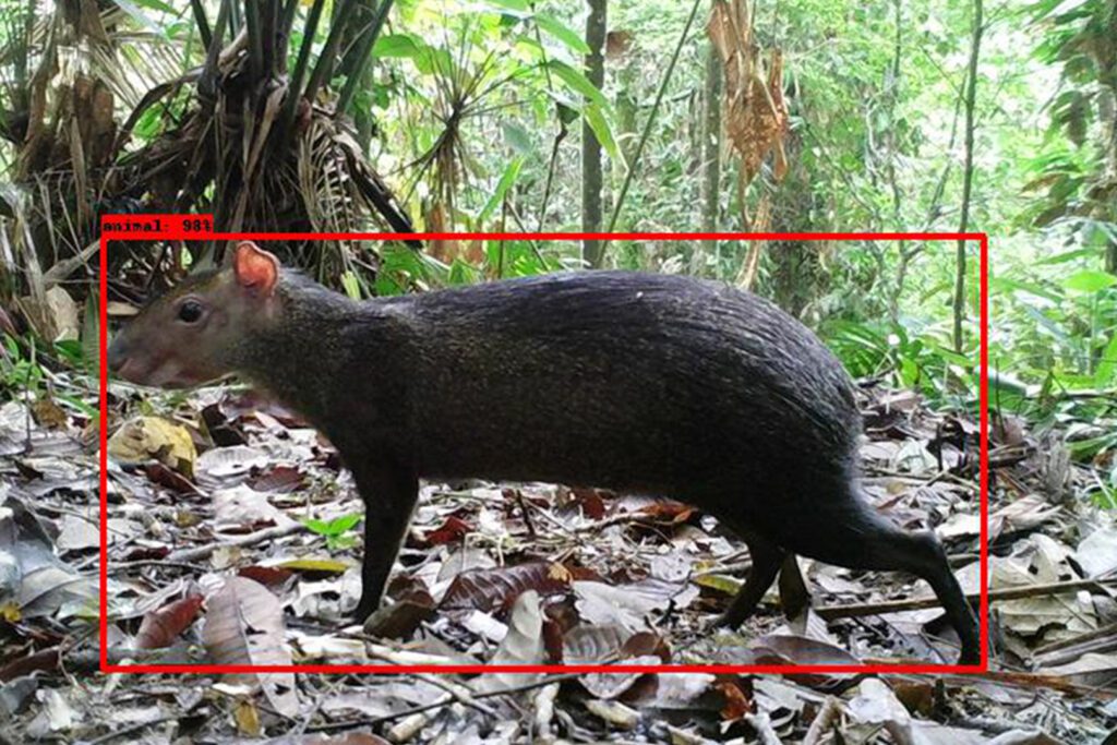
In the heart of the Colombian rainforest, an AI-driven revolution is unfolding, poised to address the persistent challenge of deforestation that has cast a shadow over the Amazon for decades. Picture this: a hidden camera trap captures an elusive agouti, a rodent-like creature belonging to the genus Dasyprocta, as it scampers through the dense underbrush under the shroud of night. In moments, an advanced AI tool, MegaDetector, identifies and categorizes the image, a task that once consumed days of painstaking effort, now distilled into mere minutes. This swiftly analyzed image is subsequently dispatched to wildlife experts for further scrutiny.
The Amazon, a sprawling expanse that spans nine nations, including Colombia and Brazil, blankets a staggering 2.3 million square miles, or 6 million square kilometers of our planet’s surface, according to NASA’s Earth Observatory. Its pivotal role in global ecology, from sequestering carbon dioxide to regulating weather patterns and providing sanctuary for diverse flora and fauna, is beyond measure.
Yet, deforestation remains an imminent threat. In 2022 alone, nearly 2 million hectares, equivalent to almost 5 million acres, of the Amazon fell victim to deforestation—a harrowing 21 percent surge from the preceding year. This rampant destruction, driven by agricultural expansion, cattle ranching, and illicit mining, is most notably rampant in regions like Caqueta in Colombia. If unchecked, the repercussions on the planet’s ecosystem could be irreversible, warn international environmental experts.
The question then arises: How does one confront such a monumental and intricate issue as reversing deforestation on a grand scale? The answer lies in the realm of Artificial Intelligence. Armed with the formidable tools of data analytics, machine learning, cloud technology, and data science, experts are forging innovative, collaborative programs aimed at detecting deforestation patterns more efficiently and equipping policymakers with the tools needed to curb this environmental crisis.
Diego Ochoa, the Director of External Affairs at the Alexander von Humboldt Institute in Bogotá, Colombia, asserts, “We need to be using technology and innovation to think outside of the box to face the problems that we have.” Collaborating with several Colombian organizations, including the CinfonIA Research Center at Universidad de los Andes, Instituto Sinchi, and Microsoft AI for Good Lab, Ochoa’s team has given birth to Project Guacamaya. This initiative harnesses cutting-edge AI models to monitor deforestation and safeguard the Amazon’s biodiversity, condensing the time required for information development by a tenth compared to manual analysis.
Project Guacamaya, also known as MACAW in English, amalgamates state-of-the-art AI models for satellite analysis, incorporating modified AI models from Microsoft for camera trap analysis and bioacoustics. These extensive databases are hosted in the cloud, with the computational might of Microsoft Azure channeled for model development and training.
Juan Lavista Ferres, Vice President and Chief Data Scientist at Microsoft’s AI for Good Lab, emphasizes the project’s significance, stating, “This project is not going to solve all the problems the Amazon has, but it is going to solve one I think is fundamental: You can’t solve a problem if you can’t measure it. By doing this, we can actually start measuring the problem.“
Project Guacamaya adopts a multimodal approach, employing satellite data, covert cameras, and acoustic recordings to generate comprehensive insights, bolster Colombian conservation efforts, and expedite analysis. This holistic methodology furnishes stakeholders with a more profound understanding of the ecosystem, enabling the formulation of pivotal reports for governmental and conservation entities to combat deforestation effectively.
Pablo Arbeláez, Director of the Center for Research and Formation in Artificial Intelligence at Universidad de los Andes, elucidates the transformation, stating, “If we can produce models with 90 percent accuracy instead of 80, we reduce a months-long effort to weeks.” This accelerated information dissemination is crucial for conservation projects reliant on carbon capture data and a more immediate response to ecosystem changes.
The project commences from the skies, where satellites, courtesy of technology partner Planet Labs PBC, capture high-resolution images of every inch of Earth on a daily basis. Project Guacamaya deploys AI models to track these images over time, swiftly identifying regions vulnerable to illegal deforestation and mining. Notably, the presence of unauthorized roads, a precursor to such activities, is readily detected through satellite imagery, enabling timely intervention by authorities.
Arbeláez underscores the significance of AI, stating, “The capacity to analyze massive amounts of data is critical here because we know that it’s a rainforest that spans countries and millions of square kilometers.” The scale and complexity of the Amazon necessitate the computational prowess of AI models to offer a comprehensive perspective.
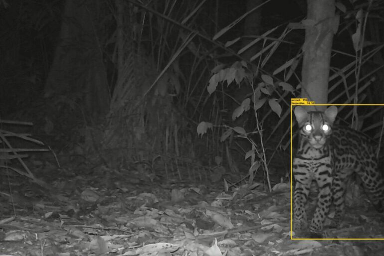
The next phase focuses on the rich biodiversity of the rainforest. Camera traps scattered throughout the Colombian Amazon continuously capture images, generating an astonishing 300,000 photos per camera. However, sifting through this trove of images manually would entail years of labor. AI programs come to the rescue, rapidly categorizing images and freeing up precious time for other research endeavors. Furthermore, quick identification of anomalies within the images can signal ecological shifts requiring immediate attention.
As Ochoa notes, “It’s like a picture in time.” The monitoring capability allows researchers to observe how plants and animals flourish. Detecting unexpected species in these images, termed bioindicators, becomes crucial for ecological insights. An avian species typically found in the savannah but now appearing in the Amazon, for instance, raises a red flag, signaling a change in the ecosystem.
The final pillar of Project Guacamaya rests on sound. Leveraging bioacoustics, researchers capture audio from the Amazon, utilizing an AI model to distinguish between bird and non-bird sounds and classify different species. This approach enhances bird identification accuracy to above 80%, a remarkable achievement considering the Amazon’s staggering diversity, boasting over 2,000 bird species in Colombia alone.
Ochoa underscores the cost-efficiency of this technology, stating, “For someone to listen to biodiversity for three months, is something that no one can afford. This technology allows us to do that in a very cost-efficient way.”
Protecting the Amazon requires a collaborative effort that transcends individual organizations or entities. Project Guacamaya exemplifies this spirit, with numerous organizations pooling their expertise and resources to address this monumental challenge collectively.
Carlos Souza, a senior researcher with Imazon, emphasizes the importance of collaboration in Brazil’s efforts to combat deforestation and mining in the Amazon, stating, “We use PrevisIA to anticipate the risk areas and implement actions to avoid deforestation.” The collaborative effort involves Microsoft, environmental organization Imazon and nonprofit Fundo Vale Foundation, and it utilizes technology to forecast and monitor deforestation, thereby safeguarding the rainforest.
As the wealth of data and results from Guacamaya and PrevisIA continues to expand and evolve, the goal is to inspire other nations to replicate these projects, thus protecting the Amazon within their borders. Lavista Ferres underscores this commitment, stating, “All of the models we’re going to be doing will be open source. Ideally, once we finish these models, we can look at Ecuador, we can look at Perú and say, ‘We have this. Can we sync and see how you can use it?‘”
In Colombia, the aspiration is to harness the power of AI and deliver easily understandable data to instill a profound sense of responsibility for safeguarding the Amazon, both for the present and future generations. Ochoa underscores this transformative vision, stating, “We need to inspire society, and this kind of project, using technology, using innovation, using AI, hopefully, will inspire Colombians to change the way they think about biodiversity and nature.” The project seeks to foster a closer connection between people and the invaluable natural treasures within these regions, emphasizing the critical need for their preservation.

The Department of Biological Sciences at Universidad de Los Andes contributed 110,000 images collected over the past four years to help train the Al tool. Image by Alexander von Humboldt Institute
Conclusion:
AI-driven initiatives like Project Guacamaya are not only instrumental in preserving the Amazon but also heralding a promising market for AI-driven environmental solutions. As technology continues to play a pivotal role in conservation efforts, businesses specializing in AI for environmental protection stand to thrive as global awareness of biodiversity’s significance grows.

