
- Ecopia AI emphasizes a strategic approach for leveraging AI in the aerial and satellite imaging sector.
- AI enables rapid conversion of imagery into high-definition maps, revolutionizing data interpretation and feature extraction.
- Ecopia’s expertise lies in scaling image interpretation beyond human capacity while ensuring accuracy and consistency.
- AI integration amplifies value across diverse imagery types, enhancing near-real-time change monitoring and detailed analysis.
- Standardized extraction of transportation features empowers authorities with actionable insights for infrastructure planning and management.
- Success in AI implementation demands expert domain knowledge, rigorous training, and substantial investments.
- Ecopia envisions AI’s role in fostering equity, accessibility, and informed decision-making, shaping a more inclusive and sustainable future.
Main AI News:
Artificial intelligence (AI) is revolutionizing the aerial and satellite imaging sector, presenting unprecedented opportunities for innovation and growth. Ecopia AI, based in Toronto, asserts that realizing these opportunities demands a dedicated strategy aimed at achieving future-ready critical success factors.
In the pursuit of becoming AI innovators ‘par excellence,’ many companies in this sector aspire to harness AI’s power to swiftly convert high-resolution multi-view imagery into high-definition vector maps. Imagine mapping an entire continent in mere months or maintaining a digital twin synced with the real world – these ambitions fuel industry dreams. However, realizing such ambitions requires more than aspiration; it necessitates a focused strategy, according to Ecopia AI.
AI-based systems offer unparalleled capabilities in replicating human-like image interpretation and reasoning, enabling the creation of map features that faithfully represent reality. Unlike conventional methods, AI can discern obscured features, like pavements under tree canopies, producing comprehensive vector layers. Achieving this level of accuracy demands rigorous neural network training to emulate human detection and contextual understanding.
Ecopia AI has earned acclaim for its AI innovation in geospatial imaging, boasting R&D teams dedicated to evolving AI systems for diverse applications like transportation planning and climate resilience. Abigail Coholic, senior director at Ecopia, underscores their future-proof mapping capabilities, emphasizing the scalability and accuracy enabled by AI.
The standard process for creating 3D features involves referencing points across the feature and determining height. AI systems excel by considering millions of points across multiple images, surpassing human capacity and minimizing errors inherent in manual digitization. Moreover, AI ensures normalized data output, critical for consistency and comparability in feature extraction results.
Value amplification across all imagery types is a hallmark of AI integration, asserts Coholic. Satellite imagery, with its frequent capture rates, benefits significantly from AI-based mapping, enabling near-real-time change monitoring. Similarly, aerial imagery’s high resolution offers granular insights, enhanced by AI’s capacity to capture intricate details efficiently.
Traditional geospatial data creation was resource-intensive, leading to infrequent updates. However, AI-driven scalability enhances data accessibility and frequency, fostering a positive feedback loop of demand and supply. Nonetheless, unlocking AI’s full potential necessitates overcoming the industry’s learning curve, emphasizing the importance of education and technology adoption.
Ecopia’s commitment extends to understanding user needs, resulting in off-the-shelf mapping products tailored to diverse applications globally. Their recent collaboration with NOAA exemplifies this commitment, delivering high-resolution land cover data to support climate resilience initiatives.
In transportation planning, Ecopia’s standardized extraction of detailed features empowers authorities with actionable insights for infrastructure management and safety enhancement. From the Illinois Department of Transportation to Network Rail in the UK, AI-driven solutions are revolutionizing transportation planning globally.
Despite AI’s monumental success, replicating Ecopia’s achievements demands expertise, rigorous training, and substantial investments. Coholic identifies expert domain knowledge, algorithm training, and infrastructure investment as critical success factors, underscoring the complexity inherent in AI implementation.
Looking ahead, Coholic envisions AI’s role in fostering equity and accessibility, highlighting the transformative potential of high-quality geospatial data. As governments harness AI for informed decision-making, the industry’s trajectory aligns with societal needs, promising a future where technological advancements prioritize humanity’s flourishing.
In conclusion, Ecopia’s journey exemplifies the transformative power of AI in geospatial innovation, emphasizing the need for strategic vision, expertise, and collaboration to realize its full potential. As the industry embraces AI, it holds the key to addressing global challenges and shaping a more inclusive and sustainable future.
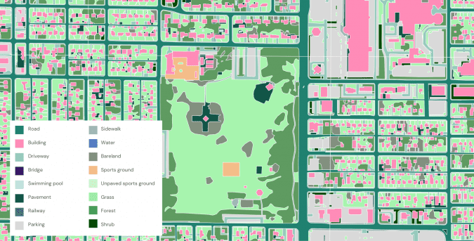
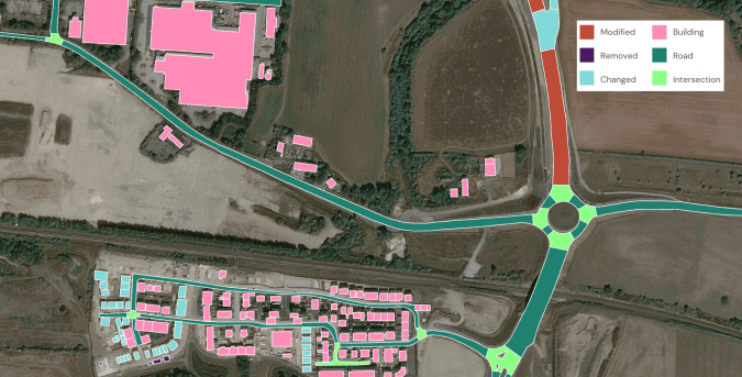
High-precision land cover map of Spokane, Washington, to inform the state’s climate resilience and sustainability initiatives. Source: Ecopia AI
Conclusion:
The integration of AI in the geospatial imaging sector, exemplified by Ecopia’s strategic approach, signifies a transformative shift towards enhanced efficiency, accuracy, and accessibility. As AI becomes increasingly integral to data interpretation and feature extraction, businesses must prioritize expertise, training, and investment to capitalize on its potential. Moreover, the emphasis on equity and accessibility underscores the societal impact of AI-driven geospatial innovation, presenting opportunities for market growth and positive societal change.