
TL;DR:
- NASA and the Pacific Disaster Center (PDC) have jointly launched the Landslide Hazard Assessment for Situational Awareness (LHASA) model to improve global awareness of landslide risks.
- LHASA utilizes machine learning, combining various data sources to provide real-time “landslide nowcasts” for any region, aiding disaster response and risk assessment.
- This collaboration expands the reach of LHASA, benefiting communities in developing countries and enhancing their disaster preparedness.
- The Pacific Disaster Center’s DisasterAWARE platform ensures that the data is accessible and integrates seamlessly into disaster management plans.
- The partnership builds upon previous successful collaborations and supports various disaster management agencies and humanitarian organizations.
- DisasterAWARE Enterprise extends the benefits to the business community, aiding in business continuity and risk intelligence.
Main AI News:
In a groundbreaking collaboration, NASA and the Pacific Disaster Center (PDC) have unveiled a cutting-edge tool that promises to revolutionize global awareness of landslide hazards. Developed over several years and rigorously tested, NASA’s Landslide Hazard Assessment for Situational Awareness model (LHASA) has now been seamlessly integrated into PDC’s multi-hazard monitoring and decision-support platform, DisasterAWARE. This powerful tool equips communities worldwide with the ability to identify, track, and respond to rainfall-triggered landslide threats effectively. Its overarching mission is to provide timely and critical risk awareness, reinforcing disaster resilience and saving lives and livelihoods.
LHASA’s Significance in a World Vulnerable to Landslides
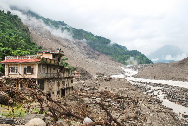
Landslides, responsible for thousands of fatalities and billions of dollars in damages annually, disproportionately affect developing countries, primarily due to limited access to early warning systems and resources for risk mitigation. The United Nations Office for Disaster Risk Reduction emphasizes the pivotal role of early warning systems and proactive measures in reducing disaster-related fatalities and losses.
LHASA’s foundation lies in a machine learning model that amalgamates data on ground slope, soil moisture, snow, geological conditions, proximity to faults, and real-time precipitation data from NASA’s IMERG product. This model draws insights from a comprehensive historical landslide database, enabling it to discern patterns indicative of imminent landslides.
The outcome is a real-time “landslide nowcast,” offering a hazard likelihood map for any given region within the previous 24 hours. This invaluable resource empowers agencies and officials to swiftly assess areas with elevated landslide risk. Moreover, it assists disaster response teams by pinpointing potential landslide sites, enabling timely deployment of life-saving resources.
Collaborative Outreach for Vulnerable Communities
While generating landslide nowcasts marks a significant achievement, the true effectiveness lies in ensuring that vulnerable communities can access and integrate this data into their disaster management plans. This is where the Pacific Disaster Center steps in.
As an applied research center managed by the University of Hawaii, PDC shares NASA’s commitment to reducing global disaster risk through innovative scientific applications. Their flagship software, DisasterAWARE, offers early warnings and risk assessment tools for 18 types of natural hazards, supporting decision-making by disaster management agencies, local governments, and humanitarian organizations worldwide. Prominent users include the International Federation of Red Cross and Red Crescent Societies (IFRC), the United Nations Office for the Coordination of Humanitarian Affairs (UN OCHA), and the World Food Programme (WFP).
The collaboration with PDC significantly expands the reach and effectiveness of NASA’s landslide tool, bringing it to tens of thousands of existing DisasterAWARE users. Already, teams in El Salvador, Honduras, and the Dominican Republic have harnessed these capabilities to assess landslide hazards during the 2023 rainy season.
PDC’s software processes LHASA model data and generates landslide risk severity maps, delivering hazard alerts to the DisasterAWARE mobile app users in the chosen region. These alerts provide crucial information, empowering communities to take proactive measures.
Moreover, DisasterAWARE creates comprehensive regional risk reports, estimating the number of people and infrastructure exposed to disasters, particularly focusing on critical elements such as bridges, roads, and hospitals. This data enables decision-makers to deploy resources effectively to areas most in need.
A History of Successful Collaboration
This joint effort between NASA and PDC builds on a history of fruitful cooperation. In 2022, they deployed a NASA global flood modeling tool to enhance DisasterAWARE’s flood early-warning capabilities. Additionally, they have shared data and expertise during multiple disasters, including Hurricane Iota in 2020, the 2021 earthquake in Haiti, and the devastating August 2023 wildfires in Maui, PDC’s base of operations.
Dalia Kirschbaum, lead of NASA’s landslides team and director of Earth Sciences at NASA’s Goddard Space Flight Center, emphasizes the openness and accessibility of the LHASA model, which leverages publicly available data from NASA and partners. This approach allows other researchers and disaster response communities to adapt the framework to regional or local applications, furthering awareness at scales relevant to their decision-making needs.
For the business community, DisasterAWARE Enterprise, provided by DisasterIQ, extends the benefits of landslide hazard alerting and impact reporting. DisasterIQ specializes in assisting businesses, from small enterprises to large corporations, in mitigating the impacts of hazards by enhancing business continuity and risk intelligence through its advanced suite of tools.
Conclusion:
The collaboration between NASA and the Pacific Disaster Center, resulting in the LHASA landslide hazard assessment tool, signifies a significant advancement in global disaster resilience. By providing accessible real-time landslide hazard awareness and expanding the reach of such critical information, this development holds the potential to enhance disaster preparedness and response capabilities, particularly in vulnerable regions. This innovation also opens opportunities for businesses to improve their risk intelligence and continuity planning, further contributing to the market’s focus on disaster management and risk mitigation solutions.