
TL;DR:
- Introduction of GF-7 Building Dataset revolutionizes building extraction from satellite imagery.
- The dataset covers diverse urban and rural areas across China, containing 170,015 buildings.
- Meticulously curated dataset ensures accuracy through manual digitization and cadastral data integration.
- Seven CNN models were tested, achieving over 93% accuracy, highlighting the dataset’s robustness.
- The dataset’s high resolution and comprehensive coverage set new standards in building extraction.
Main AI News:
In contemporary urban development and environmental analysis, precise extraction of building data from satellite images stands as a pivotal requirement for various applications. Despite technological advancements, this task encounters formidable challenges due to the intricate and dynamic nature of urban areas, particularly within China’s diverse landscape. Traditional techniques, such as pixel-based classifications, have struggled in such complex settings, prompting researchers to explore convolutional neural networks (CNNs) and deep learning methodologies. However, these sophisticated approaches are often hindered by the scarcity of comprehensive, high-quality training datasets that accurately reflect real-world diversity.
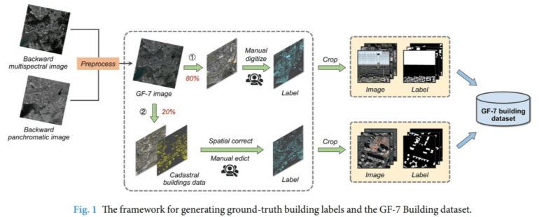
A collaborative effort led by scholars from esteemed institutions, including Sun Yat-Sen University, Southern Marine Science and Engineering Guangdong Laboratory, and China Academy of Urban Planning and Design, among others, presents a groundbreaking solution: the GaoFen-7 (GF-7) Building dataset. This dataset, meticulously curated from GF-7 satellite imagery, marks a significant milestone in building extraction endeavors across China. Comprising 5,175 pairs of high-resolution image tiles covering an extensive area of 573.17 km², it features a remarkable 170,015 buildings, providing unprecedented insights into both urban and rural structures.
The creation of the GF-7 Building dataset involved a rigorous process of manual digitization coupled with innovative utilization of cadastral building data. This approach ensured unparalleled accuracy and detail in building labels, effectively capturing the intricate geometries of structures, a feat unattainable through conventional boundary representations. With its high resolution and comprehensive coverage of urban and rural environments, this dataset emerges as a cornerstone for model training and evaluation, setting a new standard in the field of building extraction.
To assess the dataset’s effectiveness, the research team conducted extensive evaluations using seven state-of-the-art CNN models specialized in semantic segmentation. These models, ranging from the Fully Convolutional Network (FCN) 8S to the High-Resolution Network (HRNet), exhibited exceptional performance, surpassing an overall accuracy threshold of 93%. Notably, HRNet and Attention UNet demonstrated remarkable efficacy, reaffirming the dataset’s robustness and adaptability.
The unveiling of the GF-7 Building dataset couldn’t be more timely, coinciding with the growing reliance on deep learning methodologies in building extraction tasks. With its superior quality, high resolution, and diverse representation of China’s built environment, this dataset not only advances algorithm development for building detection but also serves as a pivotal benchmark for performance evaluation. It stands poised to catalyze innovation in urban planning and environmental studies, shaping the future landscape of these domains.
Conclusion:
The unveiling of the GF-7 Building Dataset marks a significant advancement in the satellite-based analysis market. Its comprehensive coverage, meticulous curation, and high accuracy levels not only enhance building extraction tasks but also set new benchmarks for dataset quality. This dataset’s availability is poised to drive innovation in urban planning, environmental studies, and various other sectors reliant on satellite imagery analysis. As organizations leverage this wealth of data, we anticipate a surge in the development of advanced algorithms and solutions tailored to address real-world challenges, ultimately reshaping the landscape of satellite-based analysis.