
TL;DR:
- Spacecraft positioning on the Moon is crucial for resource identification.
- Conventional GPS is ineffective due to the Moon’s vast distance.
- “Dead reckoning” methods can lead to significant errors.
- A new approach involves creating a crater map for precision.
- Specialized algorithms and computer vision techniques are used.
- The accuracy demanded is challenging but has broader applications.
Main AI News:
In the realm of space exploration, the question “Where are we?” carries profound weight. Unlike the impatient query of a child on a road trip, when it emanates from a space probe orbiting the Moon, it heralds a grave concern laden with potentially cataclysmic consequences. University of Adelaide’s doctoral candidate, Sofia McLeod, working diligently at the Australian Institute for Machine Learning, is acutely aware of this predicament.
McLeod’s primary focus lies in the realm of Computer Vision’s research and application for spacecraft guidance and navigation. She currently finds herself in Japan, meticulously crafting a solution to precisely determine the location of future geological survey data on the lunar surface. Such surveys bear the critical mission of unearthing invaluable resources, including minerals and water.
However, the conventional Global Positioning System (GPS) used on Earth, with its impressive ability to pinpoint mobile phone locations within meters, falters when attempting to serve the Moon. The reason lies in the vast chasm of space that separates these celestial bodies; GPS satellites orbit the Earth at approximately 20,000 kilometers, while the Moon maintains its position a staggering 384,400 kilometers away. Consequently, the GPS signals, renowned for their pinpoint accuracy, are rendered ineffective in lunar navigation. The Earth’s shadow, the interference of solar winds, and the distortion of signals during their journey to the lunar surface all contribute to this predicament.
Hence, most space probes and satellites resort to internal navigation systems. These systems employ a concept known as “dead reckoning,” wherein a spacecraft calculates its estimated position based on its speed and course. Yet, McLeod underscores a crucial caveat—these systems are susceptible to fluctuations. Perturbations caused by solar winds and the unforeseen consequences of activating onboard gyros can throw a spacecraft up to ten kilometers off course, a disconcerting margin of error for missions of such importance.
In the search for a more reliable alternative, McLeod poses a pivotal question: “What if we take a picture of what’s below us? What insights can we glean from this approach?” One proposed geological survey sensor is set to orbit the Moon at an altitude of 100 kilometers. This elevation, while inadequate for detailed surface analysis, poses another problem—it’s too low for prominent landmarks to remain in view.
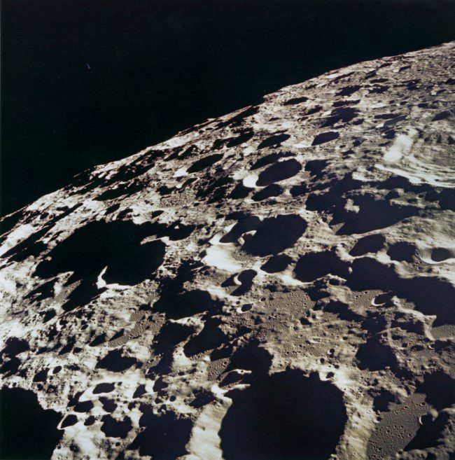
However, the Moon’s surface has already undergone extensive mapping, prompting a shift in focus to distinguish one desolate crater-pocked moonscape from another. McLeod elucidates this transition, explaining the creation of a crater map—a comprehensive list of known craters and their positions on the Moon. The ultimate goal is to synchronize resource-sensing imagery with visible surface features, aiming for a margin of error within 300 meters.
From an altitude of 100 kilometers, craters larger than 2 kilometers provide sufficient detail for individual identification. With over a million such craters scattered across the lunar surface, the presence of three or more recognizable craters in an image enables triangulation, effectively pinpointing the satellite’s position.
The University of Adelaide team, under the leadership of Professor Tat-Jun Chin, is currently hard at work developing specialized crater detection algorithms to fulfill this mission’s objectives. McLeod outlines the three essential steps to achieve accurate positioning: detection of craters in the images, matching them to entries in the known crater database, and estimation of the satellite’s position based on these matches. Machine learning techniques come into play for crater detection, while classical computer vision methods are employed for precise matching and positioning.
The level of precision demanded by this endeavor is staggering, with even the width of a single pixel capable of affecting the map’s accuracy by up to three kilometers. This necessitates a rigorous feedback loop, with constant scrutiny of the crater recognition algorithm and potential mismatches in the database. Only with meticulous attention to detail can the overarching question of “Where are we?” be definitively answered.
The scientific principles underpinning spacecraft positioning extend far beyond the lunar realm and have broader applications back on Earth. McLeod underscores the versatility of this technology, noting its relevance in scenarios ranging from landing drones to navigating rovers. The common thread in all these applications lies in teaching machines how to “see” the world, an intriguing prospect that holds vast potential for the future of technology.
In the realm of space exploration, the question “Where are we?” carries profound weight. Unlike the impatient query of a child on a road trip, when it emanates from a space probe orbiting the Moon, it heralds a grave concern laden with potentially cataclysmic consequences. University of Adelaide’s doctoral candidate, Sofia McLeod, working diligently at the Australian Institute for Machine Learning, is acutely aware of this predicament.
McLeod’s primary focus lies in the realm of Computer Vision’s research and application for spacecraft guidance and navigation. She currently finds herself in Japan, meticulously crafting a solution to precisely determine the location of future geological survey data on the lunar surface. Such surveys bear the critical mission of unearthing invaluable resources, including minerals and water.
However, the conventional Global Positioning System (GPS) used on Earth, with its impressive ability to pinpoint mobile phone locations within meters, falters when attempting to serve the Moon. The reason lies in the vast chasm of space that separates these celestial bodies; GPS satellites orbit the Earth at approximately 20,000 kilometers, while the Moon maintains its position a staggering 384,400 kilometers away. Consequently, the GPS signals, renowned for their pinpoint accuracy, are rendered ineffective in lunar navigation. The Earth’s shadow, the interference of solar winds, and the distortion of signals during their journey to the lunar surface all contribute to this predicament.
Hence, most space probes and satellites resort to internal navigation systems. These systems employ a concept known as “dead reckoning,” wherein a spacecraft calculates its estimated position based on its speed and course. Yet, McLeod underscores a crucial caveat—these systems are susceptible to fluctuations. Perturbations caused by solar winds and the unforeseen consequences of activating onboard gyros can throw a spacecraft up to ten kilometers off course, a disconcerting margin of error for missions of such importance.
In the search for a more reliable alternative, McLeod poses a pivotal question: “What if we take a picture of what’s below us? What insights can we glean from this approach?” One proposed geological survey sensor is set to orbit the Moon at an altitude of 100 kilometers. This elevation, while inadequate for detailed surface analysis, poses another problem—it’s too low for prominent landmarks to remain in view.
However, the Moon’s surface has already undergone extensive mapping, prompting a shift in focus to distinguish one desolate crater-pocked moonscape from another. McLeod elucidates this transition, explaining the creation of a crater map—a comprehensive list of known craters and their positions on the Moon. The ultimate goal is to synchronize resource-sensing imagery with visible surface features, aiming for a margin of error within 300 meters.
From an altitude of 100 kilometers, craters larger than 2 kilometers provide sufficient detail for individual identification. With over a million such craters scattered across the lunar surface, the presence of three or more recognizable craters in an image enables triangulation, effectively pinpointing the satellite’s position.
The University of Adelaide team, under the leadership of Professor Tat-Jun Chin, is currently hard at work developing specialized crater detection algorithms to fulfill this mission’s objectives. McLeod outlines the three essential steps to achieve accurate positioning: detection of craters in the images, matching them to entries in the known crater database, and estimation of the satellite’s position based on these matches. Machine learning techniques come into play for crater detection, while classical computer vision methods are employed for precise matching and positioning.
The level of precision demanded by this endeavor is staggering, with even the width of a single pixel capable of affecting the map’s accuracy by up to three kilometers. This necessitates a rigorous feedback loop, with constant scrutiny of the crater recognition algorithm and potential mismatches in the database. Only with meticulous attention to detail can the overarching question of “Where are we?” be definitively answered.
The scientific principles underpinning spacecraft positioning extend far beyond the lunar realm and have broader applications back on Earth. McLeod underscores the versatility of this technology, noting its relevance in scenarios ranging from landing drones to navigating rovers. The common thread in all these applications lies in teaching machines how to “see” the world, an intriguing prospect that holds vast potential for the future of technology.
Conclusion:
Accurate spacecraft positioning on the Moon is not only crucial for resource identification but also has significant applications on Earth, from drone landings to rover navigation. The development of specialized crater detection algorithms and computer vision techniques opens up new possibilities for precise positioning, both in space exploration and various terrestrial industries.