
TL;DR:
- Cerulean, developed by SkyTruth, is an orbital monitoring platform for coastal waters.
- It detects oil slicks and identifies responsible vessels more accurately and swiftly.
- The platform utilizes high-quality satellite imagery and synthetic aperture radar data.
- Cerulean complements human oversight and collaboration with other resources.
- SkyTruth’s recent case studies showcase the platform’s impact on environmental advocacy.
- It offers a solution for accurate pollution data, challenging existing estimates.
- Cerulean’s continued improvement and scalability make it a valuable asset.
Main AI News:
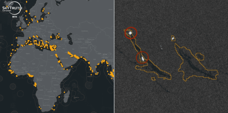
In the vast expanse of the world’s oceans, pollution often remains hidden from prying eyes, allowing wrongdoers to escape scrutiny for their actions. However, a game-changing solution is on the horizon, thanks to SkyTruth’s innovative Cerulean platform. Designed to monitor coastal waters from orbit, Cerulean not only detects oil slicks but also pinpoints the vessels responsible faster and with greater accuracy than ever before.
SkyTruth, a nonprofit organization with over two decades of experience as a watchdog and advocate in environmental crises, has long relied on satellite imagery to aid its efforts. However, it is only in recent years that the frequency and quality of satellite data have reached a level suitable for near-real-time application.
While we may not yet be able to instantly detect oil spills or leaks as they occur, many regions of the Earth now receive multiple high-definition satellite images daily, if not hourly. This wealth of data holds the potential to narrow down the time and extent of oil leaks from offshore drilling operations before they become catastrophic.
Cerulean serves as the indispensable software platform that ingests and analyzes orbital imagery and other data. It not only identifies and apprehends polluters but also provides enhanced pollution estimates for waters worldwide.
Obtaining such data directly from official sources is challenging, as they rely on indirect metrics and vessel activity reports to confirm incidents of pollution and assign responsibility. However, with satellites constantly vigilant and Cerulean analyzing the data, both the problem and its culprits can sometimes be conclusively identified from a single image.
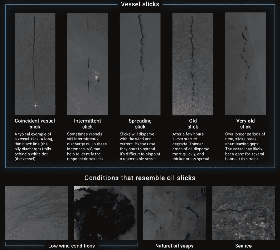
Cerulean’s capabilities extend beyond the visual spectrum, as it harnesses synthetic aperture radar data to distinguish surface textures, such as the contrast between oil and water. The platform employs a machine learning model to detect suspicious slicks or trails, enabling users to trace nearby vessels at the time of the incident.
It’s worth noting that not all apparent oil slicks result from illegal activities, as natural oil seeps, turbulence, shadows, and other factors can mimic their appearance. Additionally, many vessels, possibly a majority, evade persistent tracking via their beacons, a fact revealed by Global Fishing Watch, which coincidentally collaborates with SkyTruth.
Cerulean, therefore, functions as a valuable tool rather than a standalone solution, requiring human oversight and collaboration with other resources. Nevertheless, even individuals without expertise can utilize it, and the data it provides carries significant weight in various contexts, free from academic or advocacy biases.
For example, a 2022 study by SkyTruth highlighted that European authorities confirmed reports of 32 human-origin oil slicks. However, based on satellite data, the actual number is estimated to be approximately a hundred times higher, at around 3,000. Similarly, previous estimates suggesting that half of the oil slicks are natural were challenged by a SAR study, which suggested the true figure is closer to 6 percent. Such disparities in estimates underscore the importance of Cerulean’s contributions.
This week, SkyTruth is unveiling five case studies, offering concise reports on recent collaborations with environmental advocacy groups worldwide. Here is an overview of their endeavors:
- The Interamerican Association for Environmental Defense employs Cerulean to monitor deep-water drilling infrastructure for leaks and spills, aiming to provide daily alerts to fishermen at risk from oil slicks and depleted fish stocks.
- The Indonesia Ocean Justice Initiative strives to quantify and enhance accountability for frequent oil spills in Indonesia, a nation that, according to Cerulean data, produces as many oil slicks annually as the next five countries combined.
- Andrew Dixon, owner of a small Indonesian resort, uses Cerulean to monitor the coast of Bintan, contributing to the swift reporting of any spills. The automation of this process is a game-changer for him.
- UK climate advocacy organization Uplift utilizes Cerulean data to analyze the frequency and scale of oil spills affecting the country’s waters, advocating for an end to new oil and gas production in the North Sea.
- The 2022 report highlighting the discrepancy in bilge dumping estimates further emphasizes the need for accurate data to drive regulatory changes.
Cerulean remains a work in progress, with ongoing improvements and enhancements. Users seeking to minimize false positives can restrict the platform to high-confidence identifications. Cerulean relies solely on orbital observations and ship beacon data, eliminating the need for on-site verification.
While perfect certainty regarding the composition of slicks through satellite data alone may remain elusive, Cerulean represents the best scalable solution available. This level of visibility can only be achieved through satellites and machine learning models, making Cerulean an essential asset in SkyTruth’s 2024 plans. These plans include an improved model, user alert features, enhanced collaboration with partners, and continued engagement with concerned organizations and individuals.
Source: Cerulean
Conclusion:
Cerulean represents a significant advancement in the field of ocean pollution surveillance. Its ability to detect and pinpoint polluters with precision, complemented by real-time satellite data, is a game-changer for environmental advocacy and regulatory efforts. This innovative platform has the potential to drive change in the market, as it provides organizations and individuals with a powerful tool to combat ocean pollution and hold responsible parties accountable.