
TL;DR:
- Ohio State researchers use machine learning to convert old urban maps into 3D digital models.
- The technique can revolutionize research on historic neighborhoods and their economic impact.
- Data extracted from Sanborn Fire Insurance maps, providing insights into building details.
- Impressive accuracy of approximately 90% was achieved in generating digital models.
- The method can be applied to numerous cities and towns, enabling research on lost neighborhoods and urban changes.
- Potential applications include studying the economic impact of losses and urban heat island effects.
Main AI News:
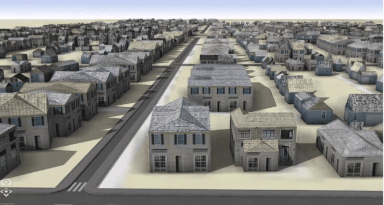
In a groundbreaking endeavor, a group of researchers hailing from The Ohio State University has successfully harnessed the power of machine learning to convert antiquated urban maps into sophisticated three-dimensional digital representations. This technological marvel has the potential to revolutionize the way we conduct research on historic neighborhoods, shedding light on the economic ramifications caused by their unfortunate demise.
Recently unveiled in the esteemed pages of the journal PLOS ONE, this cutting-edge study focused on extracting and digitizing invaluable data from Sanborn Fire Insurance maps. These maps, which dated back to the 19th and 20th centuries and were regularly updated, served as crucial tools for fire insurance companies, aiding them in gauging their liabilities across approximately 12,000 cities and towns in the United States.
Distinguished Ohio State Geography Professor, Harvey Miller, who co-authored the study, expressed the team’s excitement about their breakthrough, stating, “We now have the ability to unlock the wealth of data that are embedded in these Sanborn fire atlases. It enables a whole new approach to urban historical research that we could never have imagined before machine learning. It is a game changer.“
The methodology employed in this cutting-edge research involved the utilization of machine learning tools by Yue Lin, a geography doctoral student at Ohio State and a co-author of the study. Lin successfully extracted intricate details about individual buildings from the historical maps, encompassing crucial information such as precise locations, footprints, number of floors, construction materials used, and their primary functions. Applying this machine learning technique to two neighborhoods in Columbus, Ohio, namely Hanford Village and Driving Park, the team unearthed their vibrant pasts, before they were regrettably decimated in the 1960s to make way for the construction of the Interstate-70. These neighborhoods, once thriving Black communities, now found a new lease on life within the digital realm.
Incorporating a total of 13 Sanborn maps from 1961, the team skillfully extracted the data and skillfully rendered digital models of the lost neighborhoods. The machine learning algorithm showcased an astounding accuracy rate of approximately 90% for building footprints and construction materials. As Yue Lin eloquently put it, “We are able to get a very good idea of what the buildings look like from data we get from the Sanborn maps.“
The implications of this transformative technique extend far and wide. Researchers believe that it can be applied to nearly all 12,000 cities and towns boasting Sanborn maps, opening up an array of new research opportunities. Picture this: neighborhoods lost to the ravages of natural disasters, urban renewal initiatives, and other transformations, being reconstructed and examined for their historical and economic significance. Furthermore, the innovative approach could be instrumental in studying the urban heat island effect that emerges when residential properties are replaced by heat-absorbing highways.
Conclusion:
The utilization of machine learning to create 3D digital models from historical maps presents exciting opportunities in the market. Researchers can now delve into the past and reconstruct lost neighborhoods, understanding their economic significance. This technology could empower urban historians and researchers, opening new avenues for insights into urban development and transformation. Moreover, it offers potential applications in assessing economic losses caused by urban changes and studying the environmental effects of urbanization. As this cutting-edge approach gains traction, it may foster advancements in the fields of historical research, urban planning, and real estate analysis. Businesses in these domains could harness this technology to gain a deeper understanding of historical contexts, allowing them to make more informed decisions for the future.