
TL;DR:
- Politecnico di Milano employs AI to improve accessibility in historic city centers.
- The research focuses on identifying accessible routes in areas with challenging terrain.
- AI and Machine Learning are used to analyze pavement attributes and create thematic urban maps.
- The findings have potential applications in tourism, navigation, and urban planning.
- Collaborations with institutions and ongoing research partnerships are expanding the project’s scope.
Main AI News:
In a groundbreaking endeavor, Politecnico di Milano explores the potential of artificial intelligence (AI) to enhance accessibility in historic city centers. This innovative research aims to leverage technology and navigation devices to offer citizens valuable information, making cities smarter and more inclusive.
Historical city centers, characterized by cobblestone, sanpietrini, and brick streets with varying heights and widths, pose challenges for the elderly and individuals with motor disabilities. To address this, a young researcher at Politecnico di Milano employed AI to discern the differences in these urban features and identify the most accessible routes.
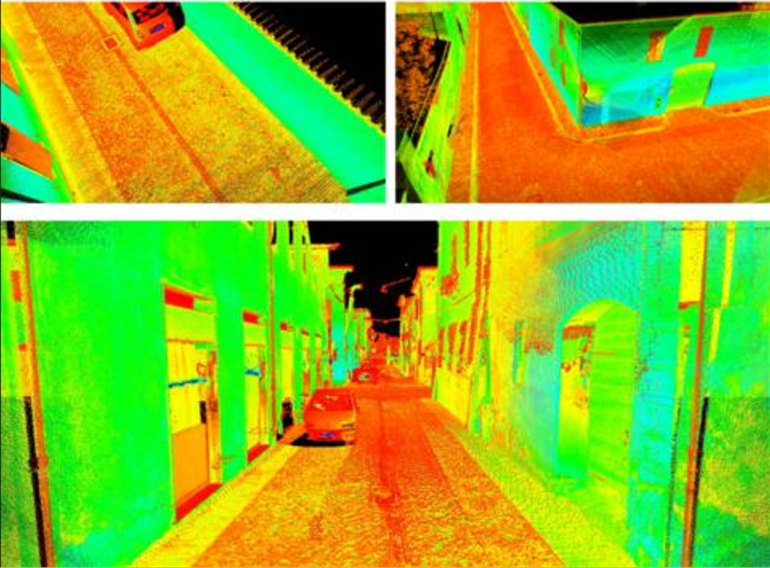
Published in the prestigious International Journal of Applied Earth Observation and Geoinformation, this research employed a mobile mapping system, utilizing a specially equipped car from Leica Geosystems Italia. The focus of this study was Sabbioneta, a UNESCO World Heritage Site known for its Renaissance charm enclosed within historic walls alongside Mantua.
“Starting from the collected data or point clouds, i.e., millions and millions of points distributed in the surveyed space that allow us to obtain measures and three-dimensional representations of what surrounds us, e.g. houses, streets, squares, pavements and various objects, it is possible to identify, with the help of Machine Learning, the most accessible trajectories and paths in a historical urban context,” explained Daniele Treccani, a researcher at the UNESCO Research Lab in Mantua at Politecnico di Milano.
Machine Learning, as elucidated by Andrea Adami, Professor of Topography and Cartography at Politecnico di Milano, serves as the backbone of this endeavor. He explained, “Machine Learning (ML) allows a complex neural network attempting to simulate the functioning of the human brain to ‘learn’ from a large amount of data previously structured by an operator. After the learning phase, it is possible, through a combination of inputs, to recognize and classify objects within the data, automatically and with no human intervention.”
In this context, Treccani continued, “The elements identified to assess physical accessibility were pavements, which are users’ preferred routes, and roads. The calculated attributes included width, height, slope, and paving material. The ML method showed good reliability of results (89%), which were verified in situ. Thematic urban maps were then produced in QGIS, accessible routes were calculated, and an update of OpenStreetMap was proposed. The work on Sabbioneta made it possible to test and demonstrate the importance of AI methods for managing accessibility in historic city centers.”
The automatic extraction of geometric and space-georeferenced information holds potential beyond this project. It can be applied to tourism accessibility and navigation, as well as the creation of map bases for Plans for the Elimination of Architectural Barriers (PEBA) or Urban Accessibility Plans. Furthermore, the data collected and processed can contribute to the construction of City Models and digital representations of historic city centers.
Daniele Treccani is committed to expanding his research by incorporating data from various urban survey systems, including UAS (drone) photogrammetry, laser scanner survey systems from aircraft, or portable systems like backpacks or handheld devices. Additionally, he continues to collaborate with the University of Vigo (Spain), a partner in the earlier phases of this research.
This pioneering research has even fostered collaborations beyond academia, extending to partnerships with the Diocese of Mantua and the Italian Bishops’ Conference. Together, they are developing a Research Project of National Interest (‘PRIN’) in conjunction with the University of Brescia, the University of Modena, and Reggio Emilia. This collaborative effort underscores the significant impact of AI in promoting accessibility and inclusivity in historic city centers.
Conclusion:
The integration of AI for enhancing accessibility in historic city centers presents a promising avenue for the market. The successful application of Machine Learning to identify accessible routes and the potential expansion into tourism, navigation, and urban planning signifies a growing demand for AI-driven solutions in the smart cities and urban development sector. Businesses should explore opportunities to provide AI-powered tools and services tailored to accessibility needs in historical urban settings, thereby contributing to more inclusive and smarter cities.