
TL;DR:
- Researchers have developed a method to create 3D digital models of lost neighborhoods using machine learning and historic Sanborn Fire Insurance maps.
- These models provide a virtual reality experience of past neighborhoods, allowing users to explore streets and buildings as they appeared decades ago.
- The technique enables urban researchers to conduct studies that were previously challenging, such as estimating the economic loss caused by demolishing historic neighborhoods.
- Machine learning tools extract details about individual buildings from the Sanborn maps, including location, footprint, number of floors, construction materials, and primary usage.
- The accuracy of the machine learning model in recreating building footprints and construction materials was approximately 90%.
- This breakthrough has vast potential, as it can be applied to nearly any of the 12,000 cities and towns covered by Sanborn maps, enabling the recreation of neighborhoods lost to various factors.
- The digital models offer new avenues for urban historical research and provide a valuable resource for studying the economic impact of urban changes and natural disasters.
Main AI News:
In a groundbreaking development for urban research, the integration of machine learning and historic Sanborn Fire Insurance maps has opened up new possibilities for recreating lost neighborhoods in stunning 3D digital models. Visualizing streets and buildings as they appeared decades ago, this cutting-edge technique allows researchers to unlock invaluable insights and conduct studies that were previously deemed nearly impossible. The economic ramifications of demolishing historic neighborhoods, for instance, can now be estimated with unprecedented accuracy.
Harvey Miller, a professor of geography at The Ohio State University and co-author of the study, highlights the significance of this breakthrough: “It enables a whole new approach to urban historical research that we could never have imagined before machine learning. It is a game changer.” Published in the esteemed journal PLOS ONE on June 28, 2023, the study paves the way for a transformative era in urban studies.
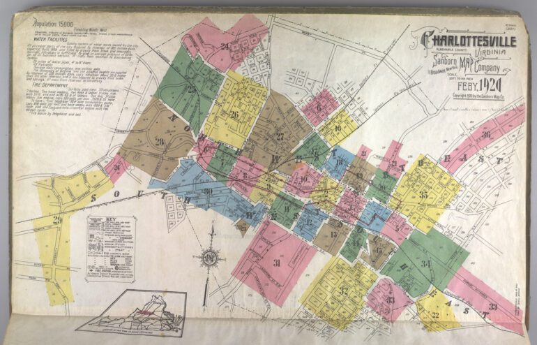
The foundation of this research lies in the Sanborn maps, meticulously crafted to aid fire insurance companies in assessing their liability across 12,000 cities and towns in the United States during the 19th and 20th centuries. While these maps were regularly updated in larger cities, manually collecting usable data from them proved arduous and time-consuming. However, with the advent of digitized versions, courtesy of the Library of Congress, the research landscape witnessed a paradigm shift.
Yue Lin, a doctoral student in geography at Ohio State and co-author of the study, spearheaded the development of machine learning tools capable of extracting intricate details about individual buildings from the Sanborn maps. These details encompassed location, footprint, number of floors, construction materials, and primary usage—whether residential or commercial. Lin remarks, “We are able to get a very good idea of what the buildings look like from data we get from the Sanborn maps.”
To demonstrate the efficacy of their machine learning technique, the researchers focused on two neighboring areas—Hanford Village and Driving Park—both decimated in the 1960s to accommodate the construction of I-70 in Columbus, Ohio. Hanford Village, established in 1946 to provide housing for Black World War II veterans, was tragically lost due to highway development. Similarly, Driving Park, once a vibrant Black community, suffered division from the construction of I-70.
By utilizing 13 Sanborn maps from 1961, just before the inception of I-70, the researchers employed machine learning to extract data and generate accurate digital models of the neighborhoods. A comparative analysis between the Sanborn data and present-day information revealed that a staggering total of 380 buildings were razed in the two neighborhoods, including houses, garages, apartments, and stores. Impressively, the machine learning model achieved an accuracy rate of approximately 90% in replicating building footprints and construction materials.
Miller expresses his awe at the results, stating, “The accuracy was impressive. We can actually get a visual sense of what these neighborhoods looked like that wouldn’t be possible in any other way.” The ultimate vision for this project is to provide individuals with virtual reality headsets, allowing them to experience firsthand the streets as they existed in the past. With the machine learning techniques pioneered in this study, it becomes conceivable to create similar 3D models for the vast array of 12,000 cities and towns encompassed by Sanborn maps.
This breakthrough has far-reaching implications for various fields of study. In addition to recreating neighborhoods lost to natural disasters and urban renewal, researchers can now delve into the economic impact of replacing businesses through digital neighborhood reconstructions. Furthermore, investigations can be conducted to examine the effect of replacing homes with highways, which absorb solar heat, on the urban heat island phenomenon. Miller asserts, “There’s a lot of different types of research that can be done. This will be a tremendous resource for urban historians and a variety of other researchers.“
Conclusion:
The application of machine learning to transform historical maps into 3D digital models represents a significant advancement in urban research. This innovation opens up opportunities for a variety of market segments. Urban historians can leverage these models to gain unprecedented insights into the past, while businesses and policymakers can utilize them to analyze the economic impact of urban transformations. Furthermore, industries such as real estate, urban planning, and architecture can benefit from virtual reality experiences that offer immersive glimpses into lost neighborhoods. The market potential for these 3D digital models is extensive, with applications ranging from historical preservation to urban development and beyond.