
TL;DR:
- Satellite imagery and machine learning reveal the true scale of the dark fishing industry, exceeding publicly available data.
- The lack of uniform tracking systems leads to unclear data on vessel numbers, operators, and catch.
- Approximately 75% of industrial fishing vessels and a third of transport and energy vessels operate under the radar.
- Satellite analysis challenges the conventional understanding of fishing distribution, particularly in Asia.
- Improved data is essential for informed policy-making and ecological monitoring.
- The presence of fishing boats in protected areas highlights law enforcement concerns.
- The open data platform from Global Fishing Watch provides real-time insights into global fishing activities.
Main AI News:
In the vast expanse of the world’s oceans, a clandestine industry thrives far beyond the reach of publicly available data. The maritime realm, a shared global resource, plays host to a shadowy network of fishing and transport vessels whose true scale eludes conventional tracking methods. This revelation, brought to light by the fusion of satellite imagery and advanced machine learning, serves as a wake-up call for policymakers worldwide.
The oceans, a common heritage, embody a complex web of customs, laws, and motivations that vary from one region to another. While the automated identification system (AIS) has gained traction as a tool for tracking vessel activity, its universal application remains elusive. Consequently, essential data such as the number of fishing vessels in a given area, their operators, and the extent of their catch often remain obscured and scattered among local, proprietary, and government-approved sources.
This informational void not only complicates policy-making but also casts a shadow of lawlessness over the industry. Countless ships covertly infiltrate restricted or protected waters while flagrantly exceeding sustainable harvest levels, endangering marine ecosystems.
Satellite imagery emerges as a game-changer in addressing this conundrum. With an unyielding eye in the sky, it exposes the clandestine activities of these vessels, but the sheer magnitude of the industry and the data required for accurate monitoring demand more than human intervention alone can provide.
In a groundbreaking study published in Nature, researchers at Global Fishing Watch, in collaboration with multiple universities, harnessed two petabytes of orbital imagery spanning from 2017 to 2021. They meticulously identified millions of vessels at sea and cross-referenced them with AIS-tracked coordinates.
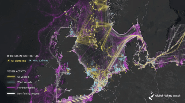
The findings lay bare a stark reality: approximately three-quarters of all industrial fishing vessels operate off the grid, escaping public tracking. Furthermore, nearly one-third of all transport and energy vessels remain in the shadows. The dark fishing industry, it appears, is as substantial as its publicly acknowledged counterpart. The imagery also sheds light on the increasing deployment of wind turbines and renewable energy sources, which is similarly challenging to monitor.
However, ‘not publicly tracked’ does not equate to complete anonymity. As Fernando Paolo from Global Fishing Watch explains, these vessels evade public tracking systems for various reasons. Smaller vessels operating in remote areas with limited satellite coverage, along with those intentionally disabling their transponders, remain invisible. Some countries employ proprietary tracking systems but restrict the sharing of this data with other nations.
Source: Global Fishing Watch
As our global population swells and ocean temperatures rise, the need for transparent data transcends national boundaries and internal agencies. Openly tracking fishing vessels is paramount for monitoring fish stocks and understanding the ecological footprint of these vessels.
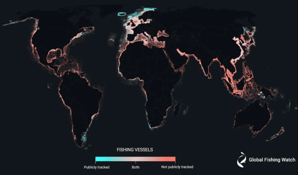
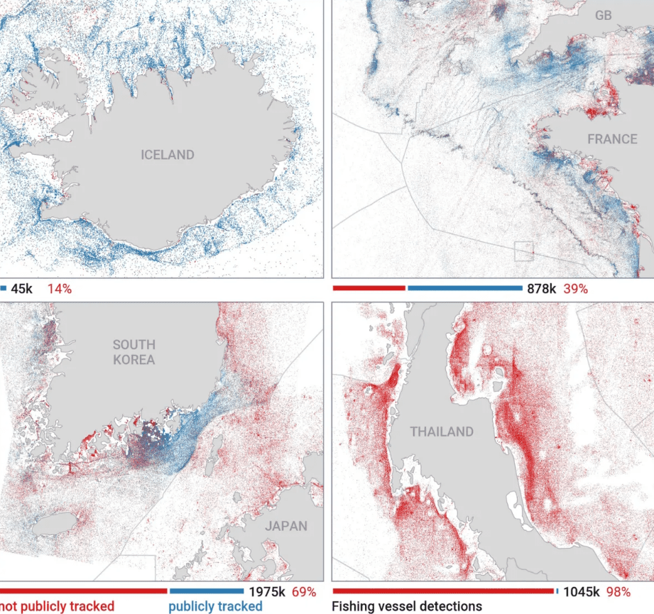
The visualizations from this study reveal regional disparities in tracking, with Iceland and the Nordics leading the way, while Southeast Asia lags far behind, especially off the coasts of Bangladesh, India, and Myanmar.
It’s essential to emphasize that this information doesn’t imply illegality but rather a lack of shared data, as mandated in the Nordics. Astonishingly, the data discrepancies uncovered by satellite imagery challenge conventional wisdom. At the same time, AIS data suggests that 36% of fishing activity occurs in European waters and 44% in Asia, satellite data paints a radically different picture. It indicates that a mere 10% of fishing vessels operate in European waters, with a staggering 71% in Asian waters, with China alone accounting for approximately 30% of global fishing.
This incongruity underscores the urgency of obtaining accurate information to inform policies and scientific research accurately. Without reliable data, both endeavors are bound to falter.
Moreover, satellite analysis reveals the recurring presence of fishing boats in protected areas, such as the Galapagos Islands, a direct violation of international law. These dark vessels have undoubtedly piqued the interest of authorities.
As we move forward, collaboration with authorities worldwide is crucial to assess these new maps and investigate fishing activities in marine protected or restricted areas. Improved data holds the potential to shape policies effectively, but the journey toward comprehensive analysis is ongoing. This initial release of our open data platform represents just the beginning, with new radar imagery constantly streaming in from the Sentinel-1 satellite, providing real-time insights into global fishing activities. Explore this data on our website, globalfishingwatch.org, where it remains up-to-date and accurate up to three days ago.
Source: Global Fishing Watch
Conclusion:
The revelation of an extensive dark fishing industry, hidden from conventional tracking methods, highlights the urgency of transparent data-sharing in the global market. Understanding the true scale of the fishing sector, particularly in Asia, challenges existing perceptions and calls for a reevaluation of policies and strategies in the maritime and environmental sectors. As satellite technology and machine learning continue to expose hidden facets of industries, collaboration with authorities and real-time data analysis become pivotal in addressing global challenges related to marine resources and sustainability.